

Extras downloads
132 829 973
downloads served for Maemo 5 (Last update: 2014-06-21 10:52)
Maep v1.3.6
Stable Quality
Downloads: 193903
Votes: 88
Free & Open Source license
Votes: 88
Free & Open Source license
Simple tile map
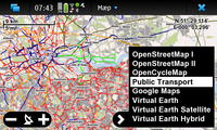
Maep is a tile based map utility for services like openstreetmap, google maps and virtual earth. This is the same map renderer that's also being used by GPXView and OSM2Go. Maep is meant to easily be included into other programs and to become a universal map widget for the Maemo5 platform.
Updated 2010-06-05 21:15 UTC
| Author | Till Harbaum |
|---|
Comments
Great! Please don't hesitate to upload such updated versions to the repositories.
Till
New version with Transport map layer, removal of ÖPVN Karte and Osmarender layers as they are not updated anymore. There's also a refresh mode that refreshes visible tiles older than 5 minutes. Press R to toggle between modes.
http://albin.abo.fi/user/jfors/saker/maep_1.3.9_armel.deb
Updated version with fixes to make OpenCycleMap work and addition of Hike & Bike Map and MapQuest: http://albin.abo.fi/user/jfors/saker/maep_1.3.8_armel.deb
great!
Hi, This app is wonderful!!! Although I have a small problem, after I installed it; the device got a little slower. I rebooted and still it is slow, I used "top" command in terminal and there was now over usage from any app and I don't have and installed skins. can anybody help?
very usefull, great
muy buena aplicación con posibilidades de cargar fácil y rápido diferentes proveedores de mapas como google maps, aunque todavía no pude generar rutas y puntos de destinos
Great solution to whoever ovi maps won't work for them.
Simple, fast, functional, my favourite quick-peek geo-app.
I wish for an option to preload OpenStreetMap I/II.
Great work.
This is maybe the best application for basic navigation. I am just now in Antigua, and OVI maps are very basic, most streets missing. Also it doesnt work with the GPS receiver. Maep found the location and also could show it on the Open street maps. How ever, as I do not have a dataplan, I would like to download the maps beforehand. Where are the pictures (or vector files) stored? Is there a way to preload them without "walking" the path a home first.
with an offline capability this app would be even better
Included public transportation maps and cycling maps make the maep unique.
How to manage the cache? (size, updating, life of cache etc.)
It uses the geonames.org database. Whatever that doesn't handle also won't be handled by maep.
Try some simple things first like "new york" and then try some more precise requests. However, street level search is not supported at all. Google can do that (see http://pagesperso-orange.fr/universimmedia/geo/loc.htm). So whoever is willing to donate some simple example how to do the required requests for google may raise his hand. I am willing to add that feature to maep.
Looks great, but somehow I Can´t use "search" option. Program keeps saying "no places matching the search term could be found", no matter what street I search.
Simple and easy.
Great application, auto caches the tiles to be usable in offline mode. Simply waiting for the POI support
One of the few usable map applications available.
A help function on how to load maps and others would be nice.
Simple but very good, i would like to see double pixel mode - street names are very tiny on n900 display and hard to read when walking or driving.
Saves the day!
Very good app, and it keeps improving. Nice job!
Hi - it keeps improving, thanks so much! I've noticed that you use geonames.org for the search feature, but not all POI from this source show up when searching.
Very good, one of the best mapping apps for N900! Please continue with the good work.
Smooth updates have two problems:
a) The map constantly moves which makes it hard to click things on the map b) This needs more updates and thus increases CPU load and thus power consumption
I see. Is it possible to increase the update-interval? It's a little bit ugly when driving (the map constantly "jumps").
very nice!
A gem, shortly put. Awesome job!
Looks promising. Is it possible to add Google Traffic to its maps?
Where can we find a changelog for this new version? BTW, nice job
I really like this application a lot. It is one of the most used ones for me. It is lightweight and not so feature bloated. Thanks for this program.
Oh man this is awesome for me! Just perfect! I'll be using this A LOT next summer with bicycle all over southern part of Finland. YESS! :)
fast and simple layout, love it!
very nice, important app, but.. as some others mentioned it can be improved to have some extra minor features...
No, that kind of tracking already works in this current version. Just hit the GPS icon and the map will follow you until you manually drag it.
No, that kind of tracking already works in this current version. Just hit the GPS icon and the map will follow you until you manually drag it.
"Tracking" as in keep-the-map-centered-on-my-gps-position? That would be five-star-good ^^
Works perfectly for me, nice job!
Shortcuts? Only the obvious ones:
Cursor keys scroll
Volume +/- zooms
f is fullscreen
Is there any shortcut keys?
Oh, thanks for that report. There is indeed a delay before the next GPS position is being processed and the circle is updated afterwards. I just fixed this in SVN, the next release will fix this.
Very slick - does one thing, and does it damn well!
The way the location "circle of doubt" reacts to zoom seems to be a little buggy though (or at least laggy).
Professional, beautiful, useful. It does a lot of location-related things for me fast and easily and for those tasks is a more than welcome replacement for the pre-installed map-application.
There could be some options for customization in the GUI, though. (Format of lat/lon, copy location, which map to start with...)
fast and smooth ! with tracking support and with POI's it will be a good map viewer for locations. Thank for your hard work
This is meant to be a very basic map utility, not much more than the bare map. I am currently adding tracking support and will also add simple POI support. But i am not planning to make it more complex as i don't really like those complex all-in-one programs like maemo mapper.
There are two solutions for you:
a) You wait for maemo mapper to become stable on maemo5
b) Someone takes my widget and makes a routing capable application from it
wow, i love this app! If only it could route directions and display points of interest? Is there any chance we could get those features added?
Comments:
You must be logged in to make comments.