

Extras downloads
downloads served for Maemo 5 (Last update: 2014-06-21 10:52)
Location & Navigation
Votes: 5
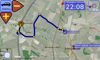
ModRana is a flexible GPS navigation system.
Votes: 47
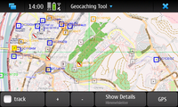
Tool for online and offline geocaching
Advanced geocaching tool for Linux downloads geocaches including their description, hints, difficulty levels and images. Searching for caches in your local database is a matter of seconds. Premium account needed for premium caches.
- Map view - supporting Open Street Maps and Open Cycle Maps by default, configurable for other map types, including google maps.
- GPS view - shows the distance and direction to the selected geocache.
- Cache details - all necessary details are available even in offline mode.
- Paperless geocaching features - take notes for a geocache on the go, see the hints and spoiler images, check the latest logs.
- Multicache calculation help - Let your phone do the math for you. Working for some of the multi-stage geocaches, AGTL finds the coordinate calculations and let you enter the missing variables.
- Fieldnotes support - Ever came home after a long tour and asked yourself which geocaches you found? Never again: Log your find in the field and upload notes and log text when you're at home. Review them on the geocaching website and post the logs.
- Text-to-Speech-Feature! - Select a target, activate TTS and put your headphones on to enjoy completely stealth geocaching.
- Download map tiles for selected zoom levels - for offline use.
- Advanced waypoint handling - AGTL finds waypoints in the geocache descriptions, in the list of waypoints and even in your notes. For your convenience, they're displayed on the map as well - see where you have to go next.
- Search for places - in the geonames.org database to navigate quickly.
- Sun compass - Compensates the lack of a magnetic compass.
- Instant update feature - Follow web site updates as soon as possible.
Votes: 618
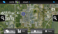
eCoach is an application for managing sport and exercise activities.
Keep track of all your sports and outdoor activities with the GPS-based eCoach application. With eCoach you can get the most from your workouts by monitoring your speed,distance and heart rate in real time. You can also use the built-in training diary feature to track your progress as you work towards your specific training goals. eCoach supports Open Street Map, Google Earth, and Virtual Earth,enabling you to view your routes on the map and share them with friends at a later point.eCoach currently supports FRWD B600 and Zephyr HxM heart rate monitors.

Votes: 24
A Journey planner/Railway Time table for many train lines in europe and australia.
Current supported backends are bahn.de (germany and europe), sbb.ch (swiss), www.131500.com.au (nsw, australia), mvv-muenchen.de (munich, germany), rejseplanen.dk (denmark), oebb.at (austria)
Votes: 25
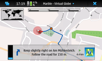
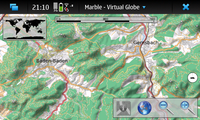
Find your way and explore the world with Marble.
Marble is a virtual globe with advanced routing capabilities. Use it as your personal navigation device to guide you to any destination in the world. Download maps from a variety of themes and explore the surroundings. Record your trip and share it with your friends.
Main features: - Online and offline routing - GPS tracking and recording (KML format) - Themable maps (OpenStreetMap, Satellite Map, many more) - Support for different projections (globe, flat map, ...) and other planets - Download of maps and route data for offline usage
Votes: 17
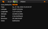
Display GPS raw data, position, speed, compass, tracking and more.
This application shows raw data from the GPS subsystem including GPS position, altitude and movement. It further offers a speedometer, a compass, a GPS track recording tool and gives you diagrams of height and speed profiles.
Votes: 12
Additional maps for marble (earth and moon)
OpenStreetMap derived map themes, educational map themes, satellite map themes, themes for other planets.
Votes: 12
Smoothest tile maps for N900 with great user experience.

Votes: 71
Geographical mapping and driving directions.
Specifically designed for the Maemo platform and the Nokia 900 form factor. It includes support for visualizing GPS input, but is functional and useful without GPS hardware. It also includes features for downloading and interacting with maps, GPX data (including driving directions), and other geo-related information. It focuses in part on in-car navigation and usability. Home page: http://www.mardy.it/mappero

Votes: 62
Complete offline geocaching solution
The GPXView application reads and displays geocaching.com GPX files and serves as a geocaching navigation tool.
Geocaching is a worldwide game of hiding and seeking treasure. A geocacher can place a geocache in the world, pinpoint its location using GPS technology and then share the geocache's location online via sites like http://www.geocaching.com.
GPXView lets you import so-called pocket queries (detailed geocaching descriptions) from those sites and allows you to view the contained information in a convenient way. Furthermore, GPXView can guide you to geocache locations using your devices built-in GPS. It also features an embedded terrain map showing you the exact location of the geocache to find the best way to approach it. Once you've